Boothstown has been farmed for as long as records exist; the name of the village was derived from the huts (or booths) used by herdsmen at least 700 years ago. The locality has been the focus of other economic activity, notably coal mining, especially after the extensive development of the mines and the building of the Bridgewater Canal in the 18th century.
The lords and trustees of the Bridgewater estates managed the industrial development of Worsley hand in hand with agriculture until the formation of Bridgewater Estates Ltd in 1923. By the mid-1830s Boothstown, which had been managed as a separate estate within the Worsley Manor since 1299, had again been incorporated within the Bridgewater lands.
Bridgewater Estates Ltd was established by a group of businessmen who bought the estates from the 4th Earl of Ellesmere. The earl had found it necessary to sell the estates in order to meet death duties on succeeding his father, the 3rd Earl, in 1914. The new company’s financial obligations to the earl (and his successor) were not met until 1948. The intervening years had seen considerable development of estate land in response to pressures from the expanding suburbs of Manchester and Salford and the need for the company to generate sufficient income to meet its financial obligations. In relinquishing management of the coal industry to a private concern, later nationalised, Bridgewater Estates became increasingly involved in suburban development. This has continued to the present day, as the Peel Estates company which bought Bridgewater Estates in 1983 administered a massive house building programme on farmland around the village.
Today Boothstown still has a rural fringe, and there are legacies of former farms throughout the area, but the 1990s sadly saw the demolition of two historic farms close to the heart of the village. These notes describe the farms of Boothstown and the surrounding area which existed in the mid-19th century and trace their story to the present day. An impression is gained of the places which helped to shape the modern village, some of which remain, and which it is hoped will not fall victim to future development. It is important that Boothstown retains the distinct character gained from its mixed agricultural and industrial heritage.
Contemporary Farms
The largest farm in Boothstown lies south of the Bridgewater Canal beyond Vicar’s Hall Bridge. The area has been farmed over many centuries, and Malkin’s Wood Farm was established by the 1st Earl of Ellesmere as one of the model farms of the Worsley estate. For most of the 19th century the farm of some 250 acres was worked by the Hamilton family. In 1851 Patrick Hamilton, aged 75, was the ‘farmer of 250 acres, employing 6 servants and men’. He lived with his wife Elizabeth (60) and their family. In 1871 Elizabeth Hamilton, now a widow aged 80, ran the 240 acres of Malkins Wood Farm with five labourers. However, Mrs Hamilton was living at nearby Rawsons i’ th’ Nook farmhouse in 1871; a farm labourer called Robert Brown (55) was at Malkins Wood.
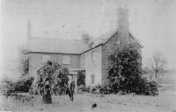
By 1891 Joseph Partington (aged 44, and originally from Culcheth) was the farmer – he lived at Malkins Wood Farm with his wife, Ann, and their family. The photograph below is believed to show Joseph and Ann Partington at the farmhouse.
In 1901 the head of household at Malkins Wood Farm was Robert Robinson (aged 48), who was described as a farm bailiff. With the Robinson family were several farm workers, including Robert King (21), a ploughman, and James Plant (24), a cattleman.
In 1911 there were two households recorded at Malkins Wood Farm (presumably at the actual farmhouse and a cottage): Arthur Gudgeon (37) was the farm foreman and lived with his family; Albert England (37) was a ‘hudsman’ (herdsman?) on the census transcript – he lived with his family and a farm labourer called George Walker (24).
The tradition of long family tenancy continued until the early 2000s through the Topp family which ran the farm from the 1940s. In the 1990s Malkin’s Wood Farm produced grass to be dried for Topp Grass animal feed; maize, flax and linseed were among other crops grown.
Malkins Wood Farm is now managed along with Moss House Farm. In 1851 Issac Hesketh (aged 31) and seven labourers worked the 185 acres. By the late 19th century Moss House Farm was run by the Hampson family. In 1871 Thomas Hampson (52) was the farmer of 180 acres – he employed 6 labourers and 1 boy’. Thomas Hampson (73) still ran the farm in 1891; he lived at Moss House Farm with his wife Martha (61) and son William (28 and single), who was described as a farmer’s assistant. William Hampson (now 38) was the farmer in 1901, and he lived at Moss House Farm with his family. In 1907 an annual rent of £265 was paid on the farm’s 148 acres. In 1911 William Hampson (49) was still the farmer at Moss House Farm.
By the year 2000 all farms south of the Bridgewater Canal were potentially affected by plans of Peel Holdings to develop a ‘forest park’ and racecourse in the area. These did not come to fruition.
Rawson’s i’ th’ Nook lies in the far south-west corner of Worsley, to the south of Astley village. Now a private dwelling, the farm was run by the Pollit family for much of the 19th century. The 37 acres paid an annual rent of £34 in 1907 when Robert Ashcroft was the tenant farmer. The last tenant was his son, John Ashcroft.
Love’s Egg Farm was, until recent years, situated just south of Leigh Road at Booth’s Bank. The farm was formerly known as Booth’s Bank Farm, and extended over 33 acres in 1764, when John Farnworth was the farmer. The Tongue family ran the farm in the early 19th century. In the second part of the 19th century it seems that there were two separate farms in this area, run by the Halliwell, Warburton and Smethills families. Alice Halliwell (58) managed 16 acres in 1851; a further 29 acres was farmed by Ann Warburton (a 73 year old widow). The 51 year old John Halliwell was the named farmer in the 1861 census. In 1871 John Smethills was a farmer of 101 acres with 3 labourers – his address was 4 Cook Lane. Also in 1871 John Halliwell (65) of 5 Booth Bank was the farmer of 30 acres. In 1881 and 1891, John Smethills was the farm bailiff, while Samuel Wheeler (53) was recorded as farmer and coal merchant in 1891; he lived with his wife, Elizabeth, and their large family. A farm of 32 acres is recorded at 103 Chaddock Road (now Leigh Road, Boothstown) in 1881, when Mary Halliwell (a widow of 65 years) farmed 32 acres.
Common Head Farm lies to the north of New Manchester village, north of Mosley Common. Mary Hindley (aged 70) worked the 60 acres of Common Head Farm in 1861, and Samuel Higginbottom was the farmer in 1871 and 1881. He was succeeded by his son-in-law, Richard Higginbottom from 1889 to 1913. Later tenants included James Grundy (1914-1915), Thomas F. Taylor (1921-1938), and James Locker (1939). Common Head Farm is associated with Ellenbrook Chapel and the Dame Dorothy Legh Charity.
Leyland’s Farm is also in New Manchester. The 1896 map shows it to the south-west of the hamlet, by the railway line, though the present farmhouse is located a few hundred yards to the north-east. The old farm was very small, with Robert Clare (aged 60) working just 3 acres in 1851.
Booth End Farm (also known as Lilly’s from the 1950s) was situated to the east of Vicar’s Hall Lane, Moss Lane and Boothstown Bridge. The farmhouse was at the junction of Vicar’s Hall Lane and Leigh Road, behind St. Andrew’s school, in the very heart of Boothstown village. Until the house was demolished in 1993 (to make way for a new road serving the houses being built on its fields), the grazing sheep so close to the village centre contributed greatly to the atmosphere of Boothstown, and the feeling of openness. The farm was run by Thomas Warburton (he is present on the 1861 census, he is aged 61 in 1871 when he was the farmer of 22 acres, and aged 81 in 1891) and later by his daughter Elizabeth Warburton in 1907, when the 36 acres paid an annual rent of seventy pounds, seventeen shillings and tenpence.
A similar loss was Grange Farm, located at the junction of Vicar’s Hall Lane and Moss House Lane. The house was demolished in 1996 as housing development spread south of the village to the canal. In the late 19th century, James Patrick farmed 23 acres. In 1891 James Patrick (54) of Grange Farm was described as a commercial traveller in the census. In 1901 James Patrick was aged 63 and described in the census as a famer of his ‘own account’. In 1907 his wife Agnes Johnston Patrick paid an annual rent of £60: she managed 8 acres, with the rest of the farm let to James, Agnes and William Johnston Patrick. In 1910 William Johnston Patrick farmed 23 acres, with an annual rent of £50.
There were a number of cottages at Boothstown Bridge, on Moss House Lane. The 1871 census records George Stephenson (36) of 10 Boothstown Bridge as a farmer.
Booth’s Hall Farm (also known as the pig farm) lay between the two Booth’s Halls, and also fell to housing development, closing in the 1960s. Census returns show Robert Lansdale (aged 41 in 1851) as Bridgewater Trustees agent, and farmer of 176 acres, between 1851 and 1891. Robert Lansdale (81, described as ‘agent and farmer’ in 1891) was resident in the new Booth’s Hall from 1846 to 1891. In 1891 John Deakin, a 45 year old salesman, lived at Booth’s Hall. In 1901 George Cook (64, a coal merchant) lived at Booth’s Hall Farm. The 1871 census records Samuel Robinson (37) of 1 Booth Hall Lane as famer of 30 acres and Joshua Edge (55) of 2 Booth Hall Lane as famer of 8 acres and local methodist preacher.
Off Chaddock Lane, a little beyond the former Queen’s Arms inn, were Chaddock Hall Farm and Oliver Fold. Chaddock Hall Farm was the home of Miles Arrowsmith, a manufacturer of cord, quilting and Indian jeans in 1825. He died there aged 73 on 7th October 1839, a tenant of Lord Francis Egerton, when the farm covered 13 Cheshire acres. The farmer was Robert Smith in 1836, and in 1847 Peggy Arrowsmith had the farm, and William Smith the cottage, which was at the entrance to Park Lane. Two other cottages on the opposite side of Chaddock Lane were tenanted in 1847 by William Hope and Richard Fish. James Mort was the farmer of 13 acres in 1871, and the farm was also worked by William Parker and William Peter Unsworth. Until 1960 Jack Hurst produced oats and grass.
Oliver Fold was a small farm which produced potatoes. Its original name was Oliverson’s. In 1595 Hugh Oliverson lived at the farm, which formed part of the Chaddock lands, and in 1656 Thomas Oliverson, husbandman, died there. He had 3 sons: Oliver, Thomas and William, and a son Thomas Haddock in Ireland, who was left 10s ‘in case he come over to the house and want the same’. Thomas’s goods were worth £45 8s 3d. In 1861, the farmer of 31 acres was Thomas Gates, aged 60. The Oliver Fold house on Chaddock Lane was demolished in the early 2000s and replaced by housing.
The former Queen’s Arms inn on Chaddock Lane (now at the junction of the A580 road) was attached to a farm. Thomas Cockshout was the innkeeper and famer of the Queen’s Arms Farm in 1871.
John Jones (74) was famer of 8 statute acres in 1871. His farmhouse appears on the census enumerator’s route between the Queen’s Arms and Chaddock Row (a row of cottages near the former Chaddock Colliery – today the site of Chaddock Row is on Linden Road, off Chaddock Lane).
A little further along Chaddock Lane was Chaddock Lane Farm – this was a working farm until around 2008 when the house was demolished. In 1871 Henry Cook (47) was the farmer of 21 Cheshire acres. In 1911 Chaddock Lane Farm was run by James Hurst, aged 49.
Historic Boothstown Farms
William Grundy (67) of 68 Boothstown Lane was the farmer of 31 acres in 1871. Thomas Warburton of 109 Boothstown Lane was the famer of 22 acres in 1871. [Note: these locations need to be more precisely identified, but the latter was on Vicar’s Hall Lane, as it became know, near Hope Farm.]
Along Vicar’s Hall Lane, a few hundred yards west of the Grange Farm house were Hope Farm (also known as Fitzpatrick’s) and Grove Farm.
Grove Farm was run by Samuel Smith in 1871 (when he was a farmer of 36 acres, with one labourer), 1881 and 1891 – he was aged 69 in 1891 and lived with his wife Mary. On the 1901 census Grove Farm was occupied by Mary Smith, a 73 year old widow, living ‘on own means’.
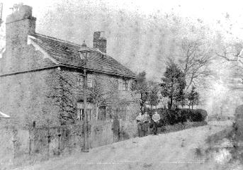
Grove Farm was run by William Wilshaw in 1907, when the 39 acres returned an annual rent of £80. Pictured below is Grove Farm around 1900.
Hope Farm was the home of Henry Smith and his wife Mary (nee Parker) until 1845; their seven children were born there between 1821 and 1837. Henry and Mary had disappeared from census returns by 1851 (Henry died in Manchester in 1859), but Henry’s brothers, John and Robert, and his sister Ann (all unmarried) were living there in 1851 and 1861. Earlier in the century, Robert and Ann had lived at Chaddock Hall Farm. In 1871 Anne Smith (72, and described as a ‘lady’) was the head of household at Hope Farm. In 1891 Hope Farm was the home of James Benjamin Edmonds, a 44 year old linen and cotton buyer.
(For more information on the Smiths of Hope Farm, and their importance in the local cotton industry, see the Windmills and Cotton Mills page of this web site.)
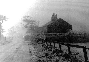
Where Vicar’s Hall Lane bends to the canal to the south there once stood a cottage called Horse Hey Nook. The picture below was taken before its demolition in the 1960s. In 1901 Horse Hey Nook was occupied by Thomas Jackson, a gamekeeper, aged 46.
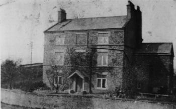
At the end of Vicar’s Hall Lane, just over Vicar’s Hall Bridge, was Vicar’s Hall Farm (pictured below). The farmhouse was occupied by the Rev. Wilson Rigg of Ellenbrook Chapel until he took up residence in the old Booth’s Hall in the mid-19th century.
Covering some 250 acres, Vicar’s Hall Farm was run by Samuel Hampson in 1851 and 1861. In 1851 Samuel Hampson (58) was a ‘farmer of 240 acres, employing 9 labourers’. He was a widower, and lived with various sons, daughters and workers. In 1871 James Hampson (46) was the farmer of 236 acres.
The farm was run by Joseph Lea (aged 68) in 1881. In 1891 Richard and Ann Rigby (27 and 23) were farm bailiffs, living at Vicar’s Hall Farm. In 1907, Richard Rigby paid £402 and six shillings annual rent on 224 acres.
Abbot’s Fold lay to the north-east of Boothstown village, off Ellenbrook Road, by the modern Abbot’s Fold Road. Thomas Cook was the farmer in 1764, and the farm was also known as Cook Lane Farm. Richard Abbot was the farmer in 1816, and Margaret Mort (aged 75) farmed 12 acres in 1861. John Mort (57) was the famer of 16 acres in 1871. Abbot’s Fold pits were sunk close by.
Around the modern Greyhound pub was the former Greyhound Farm. It was run by the Crompton family: by John Crompton in 1850, and by Robert and Fanny Crompton in 1861, when Fanny was recorded as the publican and farmer of 14 acres. In 1871 Robert Crompton (32) was the publican and farmer of 22 acres with one labourer. In 1881 at 44 Chaddock Road (now Leigh Road, Boothstown) a Mr. Andrews (aged 37) was recorded as farmer and innkeeper – this was the Greyhound inn and farm.
The modern Mosley Common Road, south of the East Lancashire Road, is sometimes referred to as Coupe’s Brow, though the use of this name has virtually disappeared. The name derives from Coupe’s Farm, which once stood just south of the point where Coupe’s Brow meets Chaddock Lane and Leigh Road. The surname of Cowoppe was transmuted to Cowper, Cooper, and Coupe. The latter is the source of the local place name. Uriah Cooper, described as a yeoman, died in 1727 when his farmstead included 5 acres of land and a cottage occupied by Richard Smethurst. His son Urian was under-age at the time of his father’s death, and a Joshua Cooper had a son Urian to whom the farm was left in the absence of a direct successor. Also in 1727 Joseph Cooper, blacksmith and stonemason, died. He was also involved in quarrying at the Delph, and his most valuable item was 20 yards of hewn stone for a bridge in Worsley, valued at £2. At the top of Coupe’s Brow, close to the modern junction of Mosley Common Road and the East Lancashire Road was New House Farm, the home of Thomas Smith, who built a windmill and a mechanised cotton mill between Coupe’s Brow and the Delph in the mid-18th century. Thomas Stanton (a Scot aged 44) was the farmer of 9 acres at New House in 1871.
Other Historic Farms around Boothstown
On the west edge of Mosley Common stood Old Fold, part of the endowment of Ellenbrook Chapel. Samuel Grundy was trustees’ tenant of its 23 Cheshire acres. No farmhouse existed in 1838; the survey of 1848 shows several buildings of the fold standing, and the 1871 census has five households recorded at Old Fold, including two heads of household who were farm labourers. Deaths recorded here include Ellen Gillibrand (1st February 1840), Peter Edge (8th January 1844), Thomas Greenhalgh (28th July 1851, aged 80), and Martha Lunn (5th June 1854, aged 54).
Brickhouse Farm was possibly the farm of the Yew Tree Inn at Mosley Common. Yew Tree Farm stood in the original Sale Lane. In 1742 John Meadowcroft paid 6s poor rate. By 1838 a Mr. Ratcliffe was the owner and the farmer was David Grundy, who was killed by his own cart on 4 November 1848. The holding covered around 18 Cheshire acres. Here in 1845, George Green of Wharton Hall sunk a shaft in search of coal; this was the beginning of the Yew Tree colliery. The 1847 map shows much woodland along the road frontage. Charlotte Grundy was at Yew Tree in 1858, and in 1871 13 acres were farmed by Richard Hurst (36), who remained there in 1881. The farmstead eventually disappeared as the colliery encroached. Near Yew Tree Farm in 1871 was the farmhouse occupied by Isaac Robinson (56) a farmer of 9 acres.
Possibly connected was Hurst Farm, also known as CWS Farm, a few hundred yards to the west. John Hurst died in 1667, and the Hurst Farm property was divided between his widow Ann and his heir, John. Ann kept the fields at the east, between the common and the brook, John the rest. The fold was for joint occupation, with all reverting to John on Ann’s death. The estate, valued at £43 1s 3d, included worklooms, bees, a musket and musket barrel. The will was witnessed by Hugh Parr, Adam Grundy and Adam Partington. Heir John occupied the farm until his death in 1719, when the farm was said to cover 10 acres, and when John’s property was valued at £29 13s 7d.
Grundy’s Farm (15 acres) and Urmston’s Farm (8 acres) were leased for £14 14s by Samuel Clowes for 99 years to Warrington School on 25th December 1782. Minerals had already been leased to the Duke of Bridgewater for £50 per year. The 1848 map shows Warrington School land west of Mosley Common, and north of Oliver Fold; this is not the same site as Turncroft, which was farmed by a Grundy family. The land was part of that sold to Robert Haldane Bradshaw in 1810. The Warrington School land valuation report of 1828 refers to the New House, on Mosley Common Road, occupied by Thomas Smith. Andrew Howarth died there 30th December 1856. Richard Smith was tenant in 1838, when the tenant of Urmston’s was Nathan Dunster, and the combined rateable value of the properties was £180.
Further north, beyond the former railway line, and to the west of New Manchester was a group of five small farms:
Thomas Hamond lived at Stonehouse Farm in 1695 and paid a chief rent of 3s 4d to the lord of the manor of Tyldesley. The same rent was paid by Henry Hampson in 1810 to the Bridgewater Trust. In 1838 Jeremiah Hampson was owner and tenant, when its area covered 15 ‘Cheshire acres’; he was still there, aged 61, in 1851. Jeremiah died on 5 February 1854, and John Hampson was drowned while drunk on 8 November 1857 (another tragedy was the drowning of James Hampson at Stonehouse on 2 September 1835). In 1855 Jeremiah’s brother-in-law William Ratcliffe tried to sell the place by auction at the Star and Garter, but the only bid, of £2,000, was not accepted. Ratcliffe lived there until 18th December 1856, when he left for Manchester, but he returned 2 years later. Elizabeth Hampson, once resident at Stonehouse, died on 29 October 1870 aged 81. In 1871 John Barlow (aged 32) worked 33 acres; he was still present in 1881 [though there is a reference to a John Barbour, aged 46, which must be checked]. A Mrs. Elizabeth Barlow was at Stonehouse in 1909.
A little to the south, but still north of the former railway, was Turncroft Farm, managed by the Grundys for much of the 19th century. Between Stonehouse and Turncroft farms was a smallholding of 1 acre called The Gore, run by William Howard (aged 69) in 1871. South-west of Common Head Farm was Platt Fold, the 11 acres of which was farmed by Benjamin Grundy (aged 71) in 1851. Roger Ashton (aged 38 in 1871) farmed Platt Fold in 1871 (16 acres) and 1881 (35 acres).
Mill Brow was a smallholding to the north of Turncroft and was the freehold of William Speakman in 1838. Jeremiah Hampson of Stonehouse took the land and leased the house to James Eckersley (died 8 January 1841). The land covered 6 Cheshire acres. Isaac Grundy lived at Mill Brow, where he died on 4th September 1829. Later Lot Lomas was located here. In 1873 William Gillibrand was tenant farmer.
Just north of Ellenbrook Chapel, near the Boundary Stone, was a small farm called Tan Pits Farm, or Tower Hill Farm. South of the chapel was a field called Windlehurst and, south of that, a field called Lower Whackers: these fields were part of Ellenbrook Farm, the largest area of which lay by the present A580 road. Ellenbrook Farm was run in 1881 by James Taylor (50 acres) and Frank Hicks (60 acres). The 1891 census records John Mort (64) as a ‘haycutter’, and James Kirkham (67) as ‘farmer’. In 1901 William Morris, aged 69, of Ellenbrook Farm was a farner on his ‘own account’. In 1907, Isabella Morris paid £70 annual rent on the 41 acres of Ellenbrook Farm. A farm known as Wackers Lane Farm may have been the same place as Ellenbrook Farm and was certainly in the same area. In 1851 and 1861 Wackers Lane Farm was run by Samuel Grundy (aged 38 in 1851) and covered some 33 acres.
Red Lion Farm
The former Red Lion pub (now private dwellings), opposite Ellenbrook Chapel, was the oldest inn in the locality, and dates back to at least 1764 when Jeoffrey Gillibrand also farmed 19 acres. The date 1729 is marked on one of the pub’s drainpipes. A red lion rampant was the main blazon on the coat of arms of the Egerton family, which owned Worsley and much of Boothstown for several hundred years until 1923.
Before being taken over by the breweries, most local inns were attached to farms, and the Red Lion was no exception. In the early 1760s, land on the east side of Newearth Road was taken into cultivation and added to the demesne farm of Worsley Old Hall. Those fields are named on the estate map of 1764 as Near New Earth, Far New Earth, Mid New Earth and Long New Earth – so it is clear why the road got its name.
John Gilbert, the Canal Duke’s famous agent and engineer of the underground canals, held the lease of this land, which became part of the Red Lion farm. When Gilbert died in 1795, his son had the lease until 1813. The Gilberts did not occupy the farm, and evidence suggests that the Newton family may have lived there. The younger Gilbert died in 1812, and in 1813 his executors gave up the lease in consideration of £8,000 paid to the 2nd Marquess of Stafford, heir to the Duke of Bridgewater; at this time it was described as a leasehold interest in the Public House and premises at Ellenbrook.
The first time the name Red Lion appears in documents specifically relating to the Ellenbrook inn is September 1823 when Mrs. Newton provided breakfast for the boundary walkers; a Richard Newton was known to have held extensive land and buildings at Ellenbrook in 1817. Newton appears to have added Gillibrand’s farm, which lay to the south, to the New Earth fields, making 43 acres in all. The land behind the inn which is now a car park was formerly a bowling green and must at one time have been the farmyard.
A hint of family tragedy is revealed in the constables’ accounts for Worsley at the end of the 18th century. In 1798 an inquest was held on Peter Newton, and in 1799 John Newton was taken to the New Bayley prison in Salford. In 1801 Richard Newton visited the prison for unspecified reasons. In 1803 Richard Newton was one of the inhabitants of Worsley liable to serve as a juror at the Court Leet and Court Baron of Worsley, and according to the constables’ accounts an inquest was held in 1808 “at the house of Richard Newton”. In 1817 he was paying a Poor Rate of £4-14s-3 and a half pence for land and buildings at Ellenbrook: a sum so large shows the size and value of the Red Lion farm. A cottage and garden at Ellenbrook, belonging to Samuel Newton, clerk of Ellenbrook chapel, was rated at just 3 shillings.
In 1821 a James Newton was described as a shopkeeper and cattle dealer. He was collecting in 1826 in aid of the distressed poor of Ellenbrook. He was probably the husband of the Mrs. Newton who had catered for the boundary walkers: the court met at the Red Lion on 2nd June 1823, but “finding it to be unfit to proceed in the walking the boundaries owing to the wet and rainy state of the weather, resolved to adjourn till eight of the clock in the morning at the house of Mrs. Newton of Ellenbrook for the above purpose”.
In 1829 Mrs. Newton still ran the Red Lion, and in 1839, during a cholera epidemic, medicines were stockpiled at inns, including Ellenbrook, in the care of Jonathan Nicholls.
In 1841, Jonathan Nicholls (aged 60) was recorded in the census as the farmer. His household included Ann Nicholls (55), Richard Nicholls (25, bookkeeper), John Newton (50, presumably the son of James), Alice Newton (35), Hannah Newton (20), and Elizabeth Gore (15, servant). Jonathan Nicholls lived with his family at the Red Lion while the Newtons were still there. He was also a juror, and served in 1832, 1834 and 1838. Jonathan Nicholls died in Ellenbrook, where he lived in a cottage near the chapel, in 1871 at the age of 90. In 1868 Richard Nicholls, son of Jonathan, was churchwarden at Ellenbrook chapel, in which capacity he was present at the official welcome to the 3rd Earl of Ellesmere when he inherited Worsley. A Joseph Newton was invited to the celebratory dinner given by the 3rd Earl to some of his tenants.
The Taylor family took over the Red Lion in 1842. They were a Worsley family with a tradition of innkeeping: Oliver Taylor had kept the Cock Hotel (then known as the Mesne Lee) as early as 1639, followed by Mary Taylor, who was there in 1722. A James Taylor was keeper of the Stocks in Walkden (locally known as the Swan, though officially called the Swan With Two Necks). From 1691 to 1744 Roger Taylor kept the White Horse in Worsley Road, Swinton, where the Select Vestry of the Township of Worsley used to meet, as it also did at the Mesne Lee. In 1830 a James Taylor and his wife assaulted the constable whilst a warrant was being served; this may have been the James Taylor who became innkeeper of the Red Lion in 1842. From that year, Taylor, like his predecessors, was liable to serve as a juror. He was also a churchwarden at Eccles church, and an official of the Township of Worsley, the equivalent in its day of a town council.
The 1851 census recorded James Taylor (aged 62) as farmer of 50 acres. His household comprised Mary (57, farmer’s wife), James (33, son, unmarried), Elizabeth (30, daughter), George (22, son, unmarried), Joseph (20, son, unmarried), and Thomas Mottershead (26, farm labourer).
By 1861, James Taylor (now aged 72, and a widower) was still the innkeeper and farmer and was described as ‘licensed victualler’. His household now consisted of James (42, son, unmarried, land agent), Elizabeth (40, daughter, unmarried, household duties), Sarah (36, daughter, unmarried), George (31, son, unmarried, agricultural labourer), Joseph (29, son, unmarried, agricultural labourer), Sarah Elizabeth (12, grand-daughter, scholar), and Mary (8, grand-daughter, scholar).
The younger James Taylor (now 53 and unmarried) was recorded as the licensed victualler in 1871. The household included George (42, brother, unmarried, farmer and licensed victualler), Joseph (40, brother, unmarried), Elizabeth (50, sister, unmarried), Sarah (22, niece, unmarried), and Mary (18, niece, unmarried).
In 1881, James Taylor (aged 63 and unmarried) was recorded as a publican and farmer of 34 acres. His household was Elizabeth (60, sister, unmarried), George (52, brother, publican and farmer of 34 acres), Joseph (50, brother, publican and farmer of 34 acres), and Mary (28, niece, unmarried).
In 1891 James Taylor (73) and his brothers George (62) and Joseph (60) were joint licensees, publicans and farmers. Their sister, Elizabeth (70 and single) was the landlady. All three were born in Rusholme, Manchester.
Probably around the turn of the century the farm may have been incorporated in Worsley Old Hall Farm. The Red Lion pub was sold to Boddington’s brewery around 1921. Subsequent Red Lion publicans included Thomas Wallwork, brother of Jesse, (1901), John Pope (1910), Thomas Henry Haden (1917), and Mrs Elizabeth Haden (1918-1921). Ernest William Griffiths was the publican between 1922 and 1927, and William Pendlebury was recorded as publican between 1928 and 1942.
Acknowledgements and Notes
The narrative on this page was written by Tony Smith based on extensive and original research by Ann Monaghan, C. Elsie Mullineux and Carol Woodward; their material was drawn from census returns, archives, newspaper reports and personal knowledge. Tony Smith provided additional census research. Additional details were drawn from John Lunn’s History of Tyldesley (1953). Farms are sometimes known by a location name, the name of a tenant farmer, a descriptive, or a nickname. Thus some farms are known by more than one name. Farms also appear to drift in and out of census returns (which are often difficult to read), although continuity is better for larger farms. The location of some farms listed in census material is unknown, probably because they were very small. The black and white photographs on this page (except Grove Farm and Horse Hey Nook) are from the collection of C.E. Mullineux. Mrs. Mullineux also provided the details on the families of the Red Lion. The photographs of Grove Farm and Horse Hey Nook were kindly supplied by Walkden Library. The notes on the Smiths of Hope Farm were taken from the family history of Judy Barradell-Smith.